Objective
Geofencing, an increasingly common feature of location-based fleet and workforce management solutions, is as emerging as an enabling technology in its own right and is poised to play a role in the development of new types of applications. Geofencing is the creation of a virtual perimeter over a real-world geographic area.
Geofences are the foundation for context-aware mobile solutions popping up everywhere in mobile marketing, CRM & workforce management, asset tracking, logistics & supply chain, government and military security and infrastructure protection, and mobile health (mHealth).
Context awareness offers several critical advantages to enterprises and consumers:
- In vehicular applications, it provides a content filter, addressing current legislation and the best practice assigned to reduce distracted driving and associated accidents
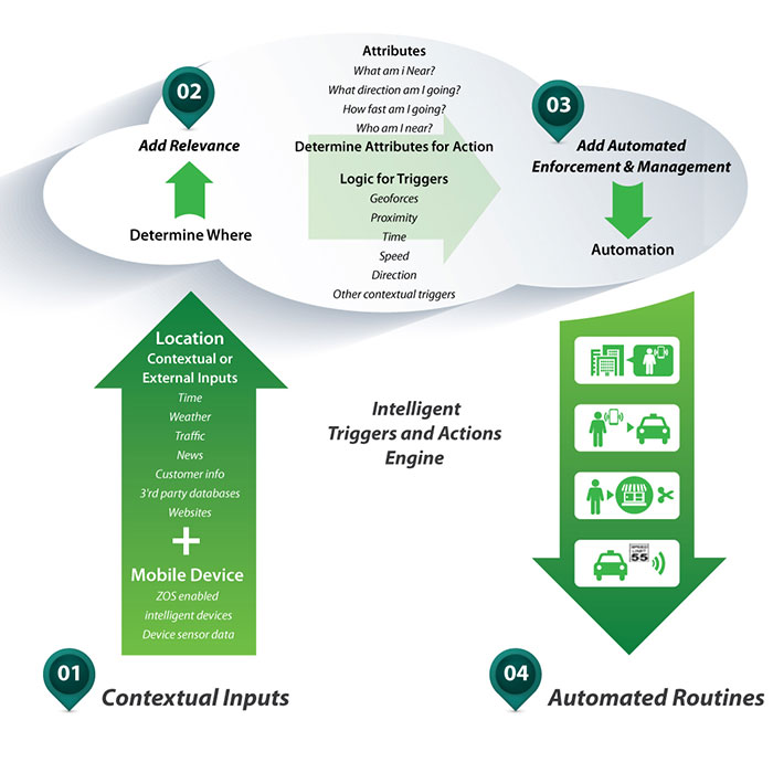
- Contextual triggering provides a powerful tool to automate wide range of business processes based on location and environment factors
- Contextual –triggered actions are a new source of value for enterprise and consumers to enjoy
Geofences can typically be set up in one of two ways:
- A geofence can be defined by boundaries on a map
- Self-centered or location-based. A self-centered geofence automatically establishes a geofence based on trailer location, for example: Once the geofence is established, the operator can set a time frame for geofence monitoring and determine what types of alerts should be used.
Ecosystem
Positioning Sensor Technology
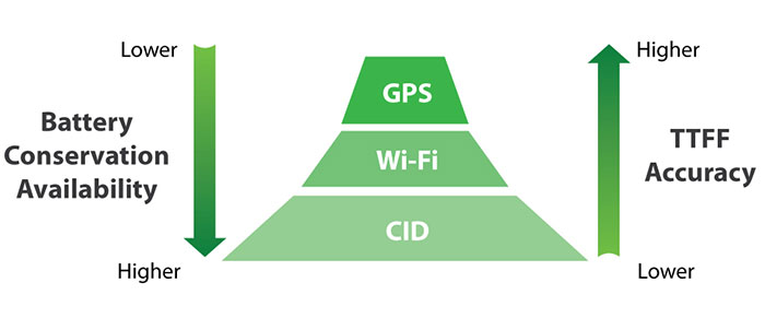
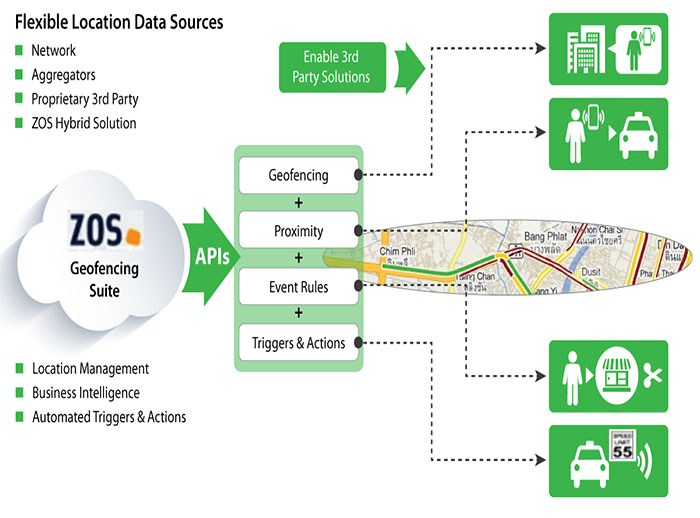
Geofencing use-cases often involve the need to reliably and accurately track devices, both indoors and out. To do so, requires the ability to use multiple location data sources, both via the device’s own sensors and 3rd party location sources, such as carrier networks, aggregators and proprietary 3rd party systems.
Elements involved in Geofencing ecosystem:
- GPS – GPS can improve location accuracy to within 5 meters of user’s location and is easily available with no extra burden on carrier infrastructure
- A-GPS – Assisted GPS (A-GPS) supplements GPS satellite information with surveyed coordinates of cell tower sites to enable more precise server-based calculation of device position
- Cell-ID(COO/CID) – Device is located by identifying the network cell tower to which it is
connected. CID positioning is simple, and can be done on the network or on the user device and does not require upgrades to network location infrastructure or mobile devices. CID provides a very rapid response time. - Wi-Fi – Wi-Fi reduces time-to-first-fix (TTFF) and is appropriate for indoor environments that obstruct satellite signals. Wi-Fi is also a viable option for outdoor positioning with the wide availability of access points in urban areas. Enterprises can benefit by using existing investments in Wi-Fi networks as location infrastructure.

The likelihood that a geo-contextual trigger fires correctly is a function of:
- Location Accuracy – The device location must be correctly determined relative to a geofence for the action to occur properly (i.e., the right user receives a notification)
- Tracking Rate – The cadence by which the device provides a location update to the server, a location is calculated, where the device is evaluated against eligible events (with associated actions)
- Device Speed – The speed a device determines the time period within which the device must provide a location update to be evaluated against eligible events (with associated actions)
- Device Route – The path a device takes across a geofenced area which affects the time period within which location update must occur. For example, the period is much shorter if the device skirts the edge of a circular geofence rather than passing through the center
- Geofence Size – A larger geofence provides a longer period for a location update, unless the device track skirts the edge of the geofence


Geofencing Current Capabilities
- POI (Point of Interest ) management
- Geo-coding and reverse geocoding
- Base Triggers
- Enter Area – Mobile user enters an area defined by a geofence
- Exit Area – Mobile user exits an area defined by a geofence
- In Area – Mobile user is in an area defined by a geofence
- Out of Area – Mobile user is outside of an area defined by a geofence
- Proximity to Another Device – Mobile user is in proximity to another mobile user
- Proximity to a Wi-Fi MAC Address – Mobile user is in proximity to a Wi-Fi access point (AP) and/or a defined Wi-Fi signal strength for a specific AP
- Speed – Mobile user is travelling less than or greater than a certain speed
- Cloud-hosted architecture provides automated scalability and reliability with minimal impact on mobile devices
- The ability to plug-in multiple location data sources —carrier networks, 3rd party location databases
- Intelligent device management with a variety of tracking options
- Geo-contextual triggers (including proximity) that address a wide range of enterprise use scenarios
- Flexible integration options via API/SDKs for both the device and server/system
- Support for nearly any type of mobile device, which reduces the cost and complexity for enterprises adopting context-aware solutions.


